Badarganj
Upazila
Badarganj (Bengali: বদরগঞ্জ) is an Upazila of Rangpur
District in the Division of Rangpur, Bangladesh.
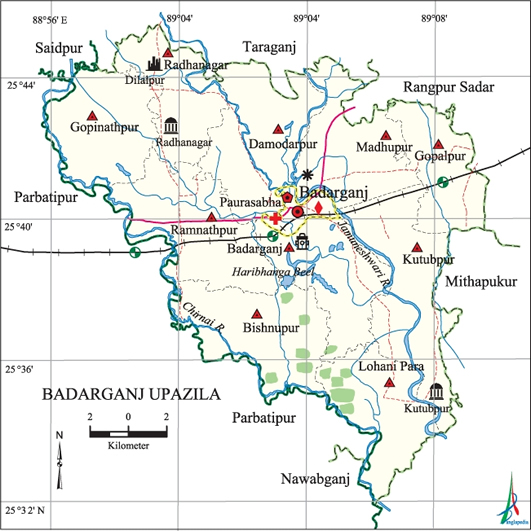
Badarganj Upazila (rangpur district) area 301.29 sq km, located in between 25°32' and
25°46' north latitudes and 88°56' and 89°10' east longitudes. It is bounded by taraganj, rangpur sadar and saidpur upazilas on the north, nawabganj (dinajpur) and parbatipur upazilas on the south, Rangpur
Sadar and mithapukur upazilas on the east, Parbatipur
upazila on the west.
Population Total
257846; male 132611, female 125235; Muslim 225502, Hindu 30073, Buddhist 1891,
Christian 66 and others 314.
Water bodies Main
rivers: Jamuneshwari, Chirnai, Katgara; Bhelakoba, Nandair, Chaprar,
Haribhanga, Bashdaha, Varardaha, Patil Vasa, Saila and' Boali beels are
notable.
Administration Badarganj
Thana was formed in 1793 and it was turned into an upazila in 1983.
Upazila
|
||||||||
Municipality
|
Union
|
Mouza
|
Village
|
Population
|
Density
(per sq km)
|
Literacy
rate (%)
|
||
Urban
|
Rural
|
Urban
|
Rural
|
|||||
1
|
10
|
64
|
120
|
31974
|
225472
|
846
|
49.3
|
36.5
|
Municipality
|
||||||||
Area
(sq km) |
Ward
|
Mahalla
|
Population
|
Density
(per sq km) |
Literacy
rate
(%) |
|||
6.79
|
9
|
12
|
23842
|
3511
|
53.57
|
|||
Upazila
Town
|
||||||||
Area
(sq km) |
Mouza
|
Population
|
Density
(per sq km) |
Literacy
rate
(%) |
||||
11.71
|
75
|
8132
|
694
|
36.14
|
||||
Union
|
||||
Name of
union and GO code
|
Area
(acre)
|
Population
|
Literacy
rate (%)
|
|
Male
|
Female
|
|||
Kutubpur
63
|
7189
|
10562
|
10023
|
29.69
|
Gopalpur
31
|
5490
|
13575
|
12629
|
38.30
|
Gopinathpur
37
|
7264
|
11476
|
11048
|
41.79
|
Damodarpur
25
|
8397
|
12495
|
11637
|
32.23
|
Badarganj
12
|
8023
|
8149
|
7675
|
33.37
|
Bishnupur
18
|
8066
|
14028
|
13382
|
33.23
|
Madhupur
75
|
7340
|
14424
|
13424
|
38.47
|
Radhanagar
82
|
5613
|
10897
|
10580
|
34.67
|
Ramnathpur
88
|
8700
|
13138
|
12813
|
49.16
|
Lohani
Para 69
|
8366
|
11390
|
10659
|
31.22
|
Source Bangladesh
Population Census 2001, Bangladesh Bureau of Statistics.
Archaeological
heritage and relics Nine-domed Mosque at Lal Dighir Par of Radhanagar
union (Mughal period), tomb of Kutub Shah at Kutubpur union, Bakhtyar Danga,
Bhim Garh at Mansinghapur, Madai Khamar, Zamindar Bari at Dilalpur, Baroari
Kali Mandir (BS. 1305) Sree Sree Praneswari Kali Mandir (BS. 1310), Gopinathpur
Ashram and Mandir (BS. 1335), ruins of Jalubar Mandir, Ghatabeel Mandir, Burir
Mandap, Shiva Mandir at Sekher Hat.
Historical
events Badarganj was a part of Barind region during the eleventh century.
The king of the Barind area, Mahipal II used to collect taxes mercilessly. As a
result the kaibarta (fishermen) community rebelled against the king in 1071.
The people of this region took part in anti British fakir-sannyasi resistance and
Krishak Praja Bidraha (peasant-tenant rebellion) during 1760 to 1812. The indigo planters of Badarganj constructed a
number of Neekhutis including Hariar Kuthi and Chandamari Kuthi. It is known
that the peasants of Badarganj participated inindigo resistance movement during
1859-1862. Besides, tebhaga movement in favour of the
sharecroppers, was held under Haji mohammad danesh of Dinajpur in
which Darajuddin Mandal, Comrade Jiten Datta, Chhayen Uddin participated.
During thewar of liberation Badarganj was
declared a free zone during April 2 to April 14. The freedom fighters destroyed
the railway lines to disrupt the movements of the Pak army. On 17 April 1971
the Pak army and their local collaborators conducted mass killings and set on
fire the villages like Khalisa Hajipur, Bujruk Hajipur, Ghatabeel and
Ramnathpur.
Marks of War
of Liberation Mass killing site 2 (Jharuar Beel and Padmapukur).
Religious
institutions Mosque 315, temple 32, church 6, sacred place 1.
Literacy
rate and educational institutions Average literacy 38.2%; male 42.83%,
female 33.3%. Educational institutions: college 7, secondary school 53, primary
school 161, satellite 9, madrasa 41. Noted educational institutions: Badarganj
Degree College, Bakshmiganj High School and College, Radhanagar Bilateral High
School (1920).
Newspapers
and periodicals daily Dainik Rangpurer Kagoj; Magazine: Batayan (BS.
1409), Sanko (2006).
Cultural
organisations Library 9, theatre group 6, theatre stage 1, women
organisation 3, cinema hall 2.
Important
establishments Shampur Sugar Mill, Bangladesh Sugar and Food Industries
Corporation.
Main sources
of income Agriculture 69.54%, non-agricultural labourer 3.32%, industry
0.48%, commerce 13.8%, transport and communication 2.25%, service 4.58%,
construction 0.75%, religious service 0.2%, rent and remittance 0.07% and
others 5.01%.
Ownership of
agricultural land Landowner 41.42%, landless 50.58%; agricultural
landowner: urban 36.56% and rural 51.26%.
Main crops Paddy,
jute, wheat, potato, mustard seed, tobacco, vegetables.'
Extinct or
nearly extinct crops Kaun, sesame, pulse.
Main fruits Mango,
banana, blackberry, jamrul, custard-apple.
Fisheries,
dairies and poultries This upazila has a number of fisheries, dairies and
poultries.
Communication
facilities Pucca road 79 km, semi-pucca road 21 km, mud road 866 km;
railway 19.31 km; waterway 29.70 nautical miles.
Extinct or
nearly extinct traditional transport Palanquin, horse carriage, bullock
cart.
Noted
manufactories Sugar mill, rice mill, flour mill, threshed rice (chira)
mill, ice cream factory, welding, steel factory, brick field, cold-storage.
Cottage
industries Goldsmith, blacksmith, potteries, weaving, wood work, sataranji
industry, bidi factory, tailoring, bamboo work.
Hats, bazars
and fairs Hats and bazars are 43, fairs 7; most noted of which are
Badarganj Hat, Laldighi Hat, Kutubpur Hat, Bagmara Hat, Faridpur Hat,
Bakshmiganj Hat, Mominpur Hat, Sekher Hat, Teker Hat, Pathaner Hat, Chilapaker
Hat, Shampurer Hat, Nager Hat, and Badarganj Mela, Bakshmiganj Mela, Sekher Hat
Baruni Mela, Karatoa Mela, Burir Parban Mela and Charak Mela.
Main exports Paddy,
wheat, mango, jute, vegetables.
Access to
electricity All the wards and unions of the upazila are under rural
electrification net-work. However 11.77% (urban 9.72% and rural 26.21%) of the
dwelling households have access to electricity.
Sources of
drinking water Tube-well 84.62%, pond 0.33%, tap 0.68% and others 14.37%.
Sanitation 7.93%
(urban 21.41% and rural 6.02%) of dwelling households of the upazila use
sanitary latrines and 18.89% (urban 26.93% and rural 17.75%) of dwelling
households use non-sanitary latrines; 73.18% of households do not have latrine
facilities.
Health
centres Upazila health complex 1, health centre 1, union health and family
welfare centre 10, private clinic 1.'
Natural
disasters Famine occurred in Badarganj in 1770, 1944 and 1947. Besides,
many people died due to epidemics like cholera and small pox. There was heavy
casualties occurred due to earth quake in 1897.


Geography
Badarganj is
located at 25°40′N 89°03′E .
It has 44029 households and total area 301.29 km². It is surrounded by Taraganj
Upazila, Rangpur Sadar Upazila and Saidpur
Upazila on the north, Nawabganj Upazila on the south, Rangpur Sadar Upazila andMithapukur Upazilas on the east, Parbatipur Upazila on the west.
Rivers and
depressions
Jamuneshwari,
Chirnai, Katgara and Chikli are main rivers that run through Badarganj.
Bhelakoba, Nandair, Chaprar, Haribhanga beels are main depressions.
Demographics
As of the 1991 Bangladesh census, Badarganj has a
population of 213431. Males constitute 51.28% of the population, and females
48.72%. This Upazila's eighteen up population is 109320. Badarganj has an
average literacy rate of 23.9% (7+ years), and the national average of 32.4%
literate.[1]
Administrative
Badarganj was
made a thana in 1905 and was turned into an upazila in 1983.[2] Badarganj
has 10 Unions/Wards, 64 Mauzas/Mahallas, and 119 villages.
Health
centres include Upazila health complex 1, union health and family welfare
centre 10, health centre 1. Religious institutions Mosque 315, temple 32,
church 6, sacred place 1. There are above hats, bazars and fairs Total in
Badarganj. The most noted hats and bazars are Badarganj, Laldighi, Kutubpur,
Bagmara, Faridpur, Bakshmiganj, Bagarganj, Mominpur hat; noted fairs are
Badarganj fair, Pirpal (Laldighi) Fair, Bakshmiganj and Badarganj fair.[2] BRAC,
ASA, Grameen bank, RDRS, Seba, Grambikash are active NGOs in Badarganj.
History
Legend has
it that Badarganj is named after the mystic-saint Hazrat Badaruddin Shah.[2] His
tomb is situated in the middle of the town.
After the conquests of Bengal, Turk Commander Ikhtiyar Uddin Muhammad bin Bakhtiyar Khilji stopped over at a field at Mansinghapur, Madai Khamar during his invasion of Tibet in 1203 AD to feed his horses.[2] After that event, the field is named 'Bakhtiyar Danga'.
After the conquests of Bengal, Turk Commander Ikhtiyar Uddin Muhammad bin Bakhtiyar Khilji stopped over at a field at Mansinghapur, Madai Khamar during his invasion of Tibet in 1203 AD to feed his horses.[2] After that event, the field is named 'Bakhtiyar Danga'.
At Jharuar
Beel and Padmapukur, mass killing occurred during the liberation war of Bangladesh.[2]
Archaeological
heritage and relics
Among
Archaeological heritage and relics are Nine-domed Mosque at Lal Dighir Par of
Radhanagar union, tomb of Kutub Shah at Kutubpur union, Bakhtyar Danga, Vhim
Garh at Mansinghapur, Madai Khamar, Zamindar Bari at Dilalpur.[2]
Cottage
industries
Badarganj is
well known for the production of shataranchi (a kind of tapestry).[2] Among
other cottage industries of the upazila are bamboo work 159, weaving 15,
goldsmith 8, blacksmith 12, potteries 20, wood work 40, tailoring 30, bidi 70.
See also
No comments:
Post a Comment