Pirgachha
Upazila
Pirgachha (Bengali: পীরগাছা) is an Upazila of Rangpur
District in the Division of Rangpur, Bangladesh.[1]
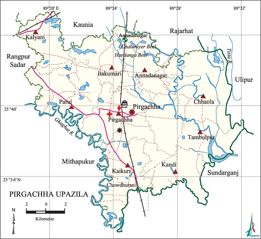
Geography
Pirgachha is
located at 25.5806°N
89.4000°E . It has 52432 households and total area 265.32 km².
Tambulpur is one of the famous Union which is situated on the Bank of river
Burail. Pirgacha upazila is situated east-south corner of Rangpur town.
Tambulpur is the largest Union of Pirgachha Upazila It is about 12 kilometers
by East-West and about 6 Kilometers by North-South. And Rahmatchar is the
Largest Village under this Union. It is situated at the very East side at River
Tista which is the meeting points of Rangpur, Kurigram and Gaibandha Districts.
Demographics
As of the 1991 Bangladesh census, Pirgachha has a
population of 256573. Males constitute 50.59% of the population, and females
49.41%. This Upazila's eighteen up population is 125484. Pirgachha has an
average literacy rate of 21.5% (7+ years), and the national average of 32.4%
literate.[2]
Administrative
Pirgachha
has 9 Unions/Wards, 171 Mauzas/Mahallas, and 189 villages. There are Two
Colleges, Two or Three High Schools and four Dakhil Madrasha. Rahmatchar is one
of the Fanous village of this Union. There are two Primary School, two Madrasha
in Rahmatchar Dewanbari is the most famous in Rahmatchar even in the Union.
Personalities
The famous
persons in the Tambulpur Union are- (1)Pandit Dewan Tozammal Hossain who was
born in 1999 and died in 1992 and his brothers (2) Dewan Ismail Hossain (3)
Dewan Ishaque were the students of Deoband Alia Madrasha of Koltata. Other
person are (4) Khandoker Ansar Ali Fakir his brother Kazi Abdur Rahman,
Mohammad Ali Mia their Cosin and Alim-A-Din Janab Nazzab Ali Mia and brother
Abdul Hai Mia (5) Janab Azgar Ali Master (Father of Harun BS, (6) Janab Nawab
Ali Master (7) Pandit Amir Hossain his brother (8) Janab Abul PP (9) Azhar
Master (10) Dewan Abu Taleb (11) Mansur Master (12) Matiar Sarder (13) Rabu
Sarder (14) Khaleq Sarder (15) Bachon Sir his father Bashanta Babu (16) Jadab
Babu, Chairman Shaheb Uddin and etc.
Pirgachha
Upazila (rangpur district) area 265.32 sq km, located in
between 25°33' and 25°45' north latitudes and in between 89°18' and 89°32' east
longitudes. It is bounded by kaunia and rajarhat upazilas on the north, sundarganj upazila on the south, ulipur and Sundarganj upazilas on the east, rangpur sadar and mithapukur upazilas on the west.
Population Total
295050; male 148650, female 146400; Muslim 268716, Hindu 25826, Buddhist 18 and
others 490.
Water bodies Main
rivers: tista, Ghaghat; Chaluniyer and Horodanga Beels are
notable.
Administration At
the time of the establishment of' Rangpur district Pirgachha was included in
the Mohiganj Thana. Later on in 1913 Nawabganj Thana was formed after
abolishing Mohiganj Thana and Pirgachha Thana was formed, as a new thana,
comprising parts of the abolished Mohiganj Thana. Pirgachha' thana was turned
into an upazila on 1 February 1984.
|
Upazila
|
||||||||
|
Municipality
|
Union
|
Mouza
|
Village
|
Population
|
Density
(per sq km)
|
Literacy
rate (%)
|
||
|
Urban
|
Rural
|
Urban
|
Rural
|
|||||
|
-
|
9
|
170
|
170
|
23931
|
271119
|
1112
|
46.94
|
38.45
|
|
Upazila
Town
|
||||||||
|
Area (sq
km)
|
Mouza
|
Population
|
Density
(per sq km)
|
Literacy
rate (%)
|
||||
|
14.29
|
5
|
23931
|
1675
|
46.94
|
||||
|
Union
|
||||
|
Name of
union and GO code
|
Area
(acre)
|
Population
|
Literacy
rate (%)
|
|
|
Male
|
Female
|
|||
|
Annadanagar
09
|
6658
|
15127
|
15135
|
42.06
|
|
Itakumari
28
|
5546
|
13426
|
12829
|
40.38
|
|
Kalyani 47
|
5061
|
12391
|
11608
|
41.68
|
|
Kandi 57
|
6227
|
13671
|
13742
|
36.56
|
|
Kaikuri 38
|
7330
|
16226
|
16321
|
37.29
|
|
Chhaola 19
|
9330
|
17888
|
18202
|
37.62
|
|
Tambulpur
85
|
9115
|
19425
|
19586
|
37.07
|
|
Parul 66
|
8044
|
18841
|
17969
|
35.86
|
|
Pirgachha
76
|
7999
|
21655
|
21008
|
43.87
|
Source Bangladesh
Population Census 2001, Bangladesh Bureau of Statistics.
Archaeological
heritage and relics Manthana Zamidar Bari, Zamindar Bari and Shiva Mandir
at Itakumari, Secret Fort at Chandipur, Tri-vigraha Mandir at Manthana,
Bhabtarini Ma Kali Mandir, Shiva Mandir at Pirgachha, Chhota Taraf Durga Mandir
at Pirgachha.
Historical
events Once Pirgachha (Manthana) constituted a zamindari estate of
Fatehpur Pargana under the kingdom of Kuchbihar. Ananta Ram, a Koch official,
surrendered to the Mughals when the latter invaded this region sometime between
1704 and 1714 and received this zamindari which lasted until 1950. fakir-sannyasi resistance were held
in this region during the period from 1760 to 1800. On 13 April 1971 the Pak
army brutally killed 11 members of the Bangali EPR at Nandiganj. The local
people buried them on the Rangpur Kurigram road side. An encounter was held
between the freedom fighters and Pak army on 2 December at Monurchhara under
Parul union in which one freedom fighter was killed and two Pak soldiers were
wounded.
Marks of the
War of Liberation Mass killing site 1 (besides the Rangpur Kurigram road).
Religious
institutions Mosque 452, temple 13, church 1, tomb 7, sacred place 5.
Noted religious institutions: Karbala Eidgah Maidan, Pirgachha Ahle Hadith
Mosque, Satdargah Mosque, Shiva Mandir at Itakumari, Tri Bigraha Mandir at
Manthana, Bhabtarini Ma Kali Mandir, Shiva Mandir at Pirgachha, Chandi and
Radha Mandir, Choto Taraf Durga Mandir at Pirgachha.
Literacy
rate and educational institutions Average literacy 39.15%; male 44.48%,
female 33.79%. Educational institutions: college 9, distant learning centre 1,
HSC program centre 1 (open university), secondary school 51, primary school
277, vocational school 3, madrasa 38. Noted educational institutions: Pirgachha
College (1970), Pirgachha JN High School (1928), Annadanagar Multilateral High
School (1950), Itakumari Bilateral High School (1921), Pabitro Jhar Government
Primary School (1932), Annadanagar Government Primary School (1942), Nachumamud
Government Primary School (1972), Pabitro Jhar Karamatia Fazil Madrasa (1950).
Cultural
organisations Library 1, club 29, theatre group 1, women organisation 3,
cinema hall 3, playground 23.
Main sources
of income Agriculture 70.06%, non-agricultural labourer 3.72%, industry
0.33%, commerce 9.85%, transport and communication 3.35%, service 3.79%,
construction 0.8%, religious service 0.2%, rent and remittance 0.23% and others
7.67%.
Ownership of
agricultural land Landowner 51.99%, landless 48.01%; agricultural
landowner: urban 44.63% and rural 52.59%.'
Main crops Paddy,
wheat, potato, sugarcane, mustard, nut, jute, betel leaf, vegetables.
Extinct or
nearly extinct crops Kaun, linseed, maize, arahar.
Main fruits Banana,
jackfruit, mango, pineapple, litchi, guava, papaya, betel nut.
Fisheries,
dairies and poultries Fishery 39.
Communication
facilities Pucca road 87.42 km, mud road 446 km; railway 21 km. Rail
Station 3 (Annadasangkar, Pirgachha, Chowdhurani).
Extinct or
nearly extinct traditional transport Palanquin, bullock cart, buffalo
cart.
Noted
manufactories Chira and muri mill 3, cotton mill 2, cold storage 5, brick
field 3.
Cottage
industries Blacksmith, potteries, bamboo work.
Hats, bazars
and fairs Hats and bazars are 21, fairs 7, most noted of which are
Pirgachha Hat, Paotana Hat, Annadanagar Hat, Sat Dargah Hat, Kaliganj Hat, Bara
Dargah Hat, Parul Hat, Nek-Mamud Hat, Tambulpur Hat, Kaikuri Hat, Kandi Hat,
Nayar Hat, Nabdiganj Hat, Deoti Hat, Sayedpur Hat, Itakumari Hat, Thanbar Mela,
Pagla Kura Mela, Chandipur Mela, Baruni Mela at Kandi, Bura Ghazir Mela,
Chaitra Samkranti Mela and Mahram Mela.
Main exports Jute,
betel leaf, betel nut, banana, potato, nut, mustard, sugarcane, vegetables.
Access to
electricity All the unions of the upazila are under rural electrification
net-work. However 12.72% (urban 11.28% and rural 30.7%) of the dwelling
households have access to electricity.
Sources of
drinking water Tube-well 93.44%, tap 0.09%, pond 0.15% and others 6.32%.
The presence of arsenic has been detected in the water of 70 shallow tube wells
out of 798. The level of arsenic is 25% in the tube well water of Annadanagar,
Chhaola, Itakumari, Kandi, Tambulpur and Pirgachha unions.
Sanitation 9.41%
(rural 8.53% and urban 20.09%) of dwelling households of the upazila use
sanitary latrines and 37.75% (rural 37.61% and urban 39.46%) of dwelling
households use non-sanitary latrines; 52.84% of households do not have latrine
facilities.
Health
centres Upazila health complex 1, satellite clinic 4, family planning
centre 9, charitable clinic 4.
Natural
disasters The devastating earthquake of 1897 and the repeated floods in
the region changed the course of the rivers, including the Tista of the region.
No comments:
Post a Comment