Mithapukur
Upazila
Mithapukur (/miːtɑːpuːkʊər/; মিঠাপুকুর Mithapukur [ˈmiʈʰaˌpukur] ( listen))
is an upazila of Rangpur District[1] in the division ofRangpur, Bangladesh. The upazila is situated in the middle
of Rangpur, surrounded by Rangpur Sadar to
the north, Pirganj to
the south, Badarganj and Phulbari to
the west and Pirgachha and Sundarganj to
the east. Mithapukur is famous for being the birthplace of Begum Rokeya
Sakhawat Hossain and its sweet mango Harivanga.
listen))
is an upazila of Rangpur District[1] in the division ofRangpur, Bangladesh. The upazila is situated in the middle
of Rangpur, surrounded by Rangpur Sadar to
the north, Pirganj to
the south, Badarganj and Phulbari to
the west and Pirgachha and Sundarganj to
the east. Mithapukur is famous for being the birthplace of Begum Rokeya
Sakhawat Hossain and its sweet mango Harivanga.
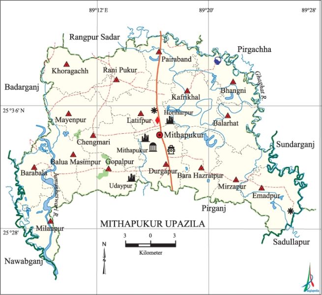
Mithapukur
Upazila (rangpur district) area 515.62 sq km, located in
between 25°26' and 25°41' north latitudes and in between 89°06' and 89°27' east
longitudes. It is bounded by rangpur sadar and pirgachha upazilas on the north, pirganj and sadullapur upazilas on the south, Pirgachha
andsundarganj upazilas on the east, badarganj and nawabganj (dinajpur) upazilas on the west.
Population Total
449612; male 230207, female 219405; Muslim 409362, Hindu 33611, Buddhist 1671,
Christian 1456 and others 3512.
Water bodies Main
rivers: Jamuneshwari, ghaghat.
Administration Mithapukur
Thana was formed in 1885 and it was turned into an upazila on 1 February 1984.
|
Upazila
|
||||||||
|
Municipality
|
Union
|
Mouza
|
Village
|
Population
|
Density
(per sq km)
|
Literacy
rate (%)
|
||
|
Urban
|
Rural
|
Urban
|
Rural
|
|||||
|
-
|
17
|
310
|
314
|
11635
|
437977
|
872
|
58.40
|
41.24
|
|
Upazila
Town
|
||||||||
|
Area (sq
km)
|
Mouza
|
Population
|
Density
(per sq km)
|
Literacy
rate (%)
|
||||
|
6.36
|
5
|
11635
|
1829
|
58.40
|
||||
|
Union
|
||||
|
Name of
union and GO code
|
Area
(acre)
|
Population
|
Literacy
rate (%)
|
|
|
Male
|
Female
|
|||
|
Emadpur 44
|
9705
|
18355
|
17088
|
34.93
|
|
Kafrikhal
55
|
8926
|
18563
|
17751
|
39.08
|
|
Khoragachh
61
|
8138
|
12898
|
12622
|
35.14
|
|
Gopalpur
50
|
6974
|
9770
|
9650
|
42.15
|
|
Chengmari
33
|
7667
|
12512
|
12417
|
39.66
|
|
Durgapur
39
|
9199
|
22642
|
21049
|
49.31
|
|
Pairaband
89
|
6826
|
13810
|
13147
|
40.73
|
|
Bara
Hazratpur 16
|
8221
|
15060
|
13902
|
45.27
|
|
Barabala
11
|
5909
|
9416
|
9175
|
41.49
|
|
Balarhat
22
|
5754
|
10948
|
10814
|
44.61
|
|
Balua
Masimpur 10
|
7599
|
9688
|
9449
|
42.36
|
|
Bhangni 27
|
6365
|
12642
|
11949
|
39.65
|
|
Mayenpur
83
|
7677
|
12109
|
11717
|
36.28
|
|
Milanpur
72
|
6283
|
9462
|
9008
|
43.06
|
|
Mirzapur
78
|
7513
|
13771
|
12796
|
42.24
|
|
Rani Pukur
94
|
7071
|
12644
|
11912
|
42.45
|
|
Latifpur
67
|
7587
|
15917
|
14959
|
47.23
|
Source
Bangladesh Population Census 2001, Bangladesh Bureau of Statistics.
Archaeological
heritage and relics House of begum roquiah (Pairaband), Turka
Mosque at Latifpur union (Mughal period), three domed Jami Mosque at village
Mithapukur, mazar and mosque of Gazi Pir at Bairagiganj, three domed mosque at
village Bhangni, house of Raja Bhavachandra and Bagdevi Mandir (extinct) at
Dhap Udaypur, Benuban Buddhist Vihara, ancient mandir of Aladipur, Zamindar
Bari at Phulchawki, Baldipukur Mission and Church, Mithapukur (pond, excavated
during the Mughal period).
Historical
events The Praja Vidraha (tenant movement) was held in Mughat Hat and
Patgram during the British rule. The people of the upazila took part in Rangpur
Cantonment raid on 28 March 1971. During the war of liberation direct encounters
were held on the border of Pirganj-Mithapukur and the Damdama Bridge areas
between the Pak army and the combined forces of the freedom fighters and the
allied troops. The Pak army conducted mass killing and plundering in the upazila
of which the most brutal was mass killing at Joyram Anwar Mouza in Pairaband
union.
Marks of the
War of Liberation Mass grave 3 (at a place on the eastern side of the tomb
of Gazi Pir at Boiragiganj, near the Damdama Bridge and Damdama Bazar); mass
killing site 5 (Damdama Bridge, Damdama Bazar, in front of the tomb Gazi Pir at
Boiragiganj, Jamuneshwari River bed at Milanpur point, backyard of Jhinuk
Cinema Hall).
Religious
institutions Mosque 650, temple 32, church 2, tomb 4, buddhist vihara 1.
Noted religious institutions: Turka Mosque at Latifpur Union, three domed Jami
Mosque at village Mithapukur, mazar' and mosque of Gazi Pir at Boiragiganj,
three domed Mosque at village Bhangni, Ancient Mandir of Aladipur village,
Baldipukur Church, Benuban Buddhist Vihara.
Literacy
rate and educational institutions Average literacy 41.7%; male 45.49%,
female 37.75%. Educational institutions: college 16, secondary school 74,
primary school 245, madrasa 110. Noted educational institutions: Mithapukur
College (1970), Shathibari College (1970), Shathibari Multilateral High School
(1958).
Cultural
organisations Library 1, club 86, theatre group 1, auditorium 1,
playground 15, cinema hall 5.
Main sources
of income Agriculture 69.47%, non-agricultural labourer 4.43%, industry
0.51%, commerce 11.27%, transport and communication 3.05%,' service 3.48%,
construction 0.8%, religious service 0.17%, rent and remittance 0.11% and
others 6.71%.
Ownership of
agricultural land Landowner 53.2%, landless 46.8%; agricultural landowner:
urban 50.4% and rural 53.27%.
Main crops Paddy,
wheat, potato, sugarcane, vegetables.
Extinct or
nearly extinct crops Jute, tobacco.
Main fruits Mango,
jackfruit, blackberry, papaya, banana.
Fisheries,
dairies and poultries Fishery 15, dairy 70, poultry 100, nursery 22,
hatchery 3.
Communication
facilities Pucca road 129.9 km, semi-pucca road 40 km, mud road 1340 km.
Extinct or
nearly extinct traditional transport Palanquin, bullock cart.
Noted
manufactories Husking mill 75, saw mill 25, oil mill 2, ice factory 10,
bidi factory 1, welding factory 20, dairy and food products 1, meat processing
industry 1, cold storage 4.
Cottage
industries Blacksmith 76, potteries 55, jute work 10, leather work 12,
bamboo work 230, tailoring 202.
Hats, bazars
and fairs Hats and bazars are 60, fairs 12, most noted of which are
Shathibari Hat, Jayagirhat, Shukur Hat, Bairati Hat, Rani Pukur Hat, Chowdhury
Gopalpur Hat, Balua Hat, Serudanga Hat, Shathibari Durga Puja Mela, Mithapukur
Bazar Puja Mela, Bairati Baruni Mela, Chowdhury Gopalpur Hat Baruni Mela.
Main exports Paddy,
wheat, sugarcane molasses, potato, vegetables.
Access to
electricity All the unions of the upazila are under rural electrification
net-work. However 11.53% (urban 48.57% and rural 10.64%) of the dwelling
households have access to electricity.
Sources of
drinking water Tube-well 91.31%, tap 0.65%, pond 0.31% and others 7.73%.
Sanitation 12.6%
(rural 11.96% and urban 39.18%) of dwelling households of the upazila use
sanitary latrines and 27.39% (rural 27.42% and urban 26.29%) of dwelling
households use non-sanitary latrines; 60.01% of households do not have latrine
facilities.
Health
centres Upazila health complex 1, union family planning centre 17, union
health centre 11, regional training centre for family planning 1.
NGO
activities Operationally important NGOs are brac, asa, CARE, caritas, thengamara mahila sabuj sangha. [Abu
Md. Iqbal Rumi Shah]
Etymology
Mithapukur
is the largest upazila in Rangpur zila in respect of both area and
population.It came into existence in 1885 as a thana and was upgraded to
upazila in 1983. Nothing is definitely known about the origin of the upazila
name. It is said that Mir Jumla II, the Subahdar of Bengal, came there
by the order of the Mughal Emperor Aurangzeb in
order to invade Koch Bihar.[2] He
set up a camp near the current Mithapukur Degree
College during the period of his military expedition in Bengal. His
forces faced an acute problem of water for which a pond was dug near the camp.
The water of the pond was so sweet that Mir Jumla named the place
"Mithapukur" (Mitha means Sweet and Pukur means Pond).
Some believe that Shah Ismail Ghazi ordered
to dig the pond. It is believed that the pond consisted of five separate ponds.
But in course of time, they mixed into a single pond.[citation needed]

Mithapukur
(then, Mettypukre) in the Dury Wall Map of Bihar and Bengal, India in 1776
The name
Mithapukur also appears in the James
Rennell's Dury Wall Map of Bihar and Bengal, India (as Mettypukre) and
N. Hindostan Map (as Mettypokra) and John
Bartholomew's Map of Provinces of the Lower Ganges (as Mitapokhar).
Geography
Mithapukur
is located at 25.5417°N
89.2833°E. It has total area 515.62 km². Mithapukur possesses vast
fertile land. The Jamunashwori, Akhira and Ghaghot are the major river flows
through Mithapukur. The Akhira river, which divided to Mithapukur landscape
into two parts. The land character of the western part of Mithapukur is red
brown soil and eastern part is locally known as Poly area, which contains a
large part of the Upazila. Gopalpur Forest is the main landmark of Terrace
soils area.
Demographics
As of the 2011 Bangladesh census,[3] Mithapukur
has a population of 5,08,133 where males constitute 2,52,325 and females
constitute 2,55,807 of the population with annual population growth rate of
1.21%. The total number of household of Mithapukur is 1,35,073. Mithapukur has
an average literacy rate of 46% (7+ years) compared to the national average of
51.8% literate and 2nd highest literacy rate among the upazila Rangpur district
followed by Rangpur Sadar.[3] [3]
Mithapukur
Upazila has a very diverse population with minority groups including Buddhists,
Christians and tribes such as Santhal who
have lived in the district from the beginning of settlement in this area.[4]
Administrative
Mithapukur
has 17 Unions, 311 Mauzas and 315 villages. The 17 unions are as follows:
Khoragach
Ranipukur
Payrabond
Vangni
Balarhat
Kafrikhal
Latibpur
Changmari
Moyenpur
balua
masempur
Barobala
Milonpur
Gopalpur
Durgapur
Baro
Hazrathpur
Mirzapur
Imadpur
Economy
Unripe
mangoes on a mango tree, Harivanga Mango
Agriculture
is demographically the broadest economic sector and plays a significant role in
the overall socio-economic fabric of Mithapukur. Mithapukur is the largest
producer of mangoes, vegetables and potatoes in the district. Mithapukur is the
birthplace of the sweet mangoHarivanga, famous for its different taste.
Tourist
attractions
Mithapukur Upazila has many historical and
attractive places. Begum Rokeya Memorial in Pairaband is the birthplace of Begum Rokeya Sakhawat Hossain (1880–1932),
an eminent educationist and a pioneer of women's liberation. Mithapukur's most
popular tourist attractions are the Mithapukur Pond-Excavated during Mughal
period, Benubon Buddhist Vihara-Mithapukur, The Mughal era three domed jami
Masque- Mithapukur, Tanka jami Mosque at Latibpur and Gopalpur forest and Eco
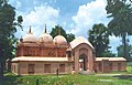
Mithapukur
Mughal Era Masque
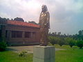
Statue of
Begum Rokeya near Begum Rokeya Memorial
Notable
people
H N Ashequr
Rahman,Parlamment member, entrepreneur
Rashid
Askari, writer, academic
Road
communication
Mithapukur
is well connected to Dhaka, Rangpur, Bogra by
National highway. Mithapukur can be reached by the 304 km long National
highway(N5) from Dhaka. The highway also provides a link to the neighbouring
divisional town Rangpur by 18 km from Upazila Sadar. Highway buses run
from kallanpur, Dhaka to Rangpur and it takes about six to seven hours.
See also
No comments:
Post a Comment